

Surveying in civil engineering, the first step of beginning a new civil engineering project, It is a very essential department of civil engineering. To recognize the methods of surveying a scholar need to cautiously find out about the fundamentals of it. To begin studying surveying one has to begin with the definition of surveying and its importance.
What You Will Learn In This?
- Surveying
- The objectives of surveying
- Classification of surveying.
- The main difference between plane surveying and geodetic surveying.
- The principles of surveying
- The basics of chain Survey
- Types of chain used in the Survey
- Compass Survey
- The difference between prismatic and surveyors compass
- Leveling
- Types of Levelling
- Conclusion
- FAQs
Surveying
We are going to learn about the basics of surveying. So, we should know the actual definition of surveying.
What is mean by surveying?
Surveying is defined as the art of determining the relative position of an object that is below the earth’s surface.
What is mean by relative position? Relative position means with respect to something.
For example, In order to specify my home, I could say that from one point my home is 10 km away, from the second point my home is 20 km away. So here 1st and 2nd points are the reference points, and my home is the object to specified. Therefore, it is called a relative position of an object.
The objectives of surveying –
The main objective is to prepare a plan or a map.
What is mean by plans?
The plans are the small scale object, which means in order to specify the boundary of any building, we can do plan.
What is mean by map?
Map means it’s a large scale object for example in order to specify a boundary of any country then we do the map.
What are the things to be taken from the plan?
We can take horizontal distance, vertical distance, and also the directions. The vertical distance taken from the map is called contour mapping.

Classification of Surveying.
The surveying in civil engineering is primarily classified into two types. There are two types first one is plane surveying the second one is geodetic surveying.
Plane surveying
when the surveying area is less than 250 kilometer square then we can say it is plane surveying.
Geodetic surveying
when the surveying area is greater than 250 kilometer square then we can say it is Geodetic surveying.
The main difference between plane surveying and geodetic surveying.
Plane surveying here the serving area is taken into account but in geodetic surveying, the curvature of Earth is taken into account so this is the main difference between plane surveying and geodetic surveying in civil engineering.
The Principles of Surveying
There are two principles of surveying. The first one is to work from whole to part and the second one is to locate a new station by measuring two reference points.
First principle
To work from whole to part.A larger area divided into smaller number of triangles.

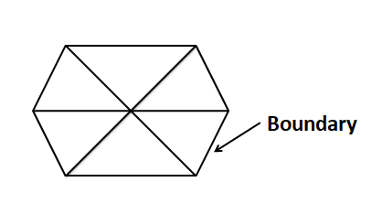
Example: Consider hexagon, sides is the boundary of this hexagon. Sidelines is the boundary and In between these lines is a larger area. Now we divide this boundary into a smaller number of triangles. Now by measuring the area of these small triangles we can easily measure the area of this boundary so this is the first principle. the process of splitting this area into a small number of triangles is called triangulation. In this surface principle, the benefits of the error that occurred during computing can be easily eliminated. so this is the first principle.
Second Principle
To locate the new station by measuring two reference points
Example: Consider, if you want to locate a new station. The new station will be R. To locate this new station we need two reference points. So, I’m going through these two reference points. So, P is one reference point. S is one reference point. So, consider P is one building, and S will be another building.

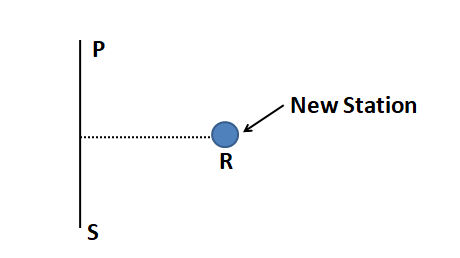
Firstly, We have to measure the distance between these two buildings P and S. When we measure the distance between these buildings P and S, We can easily draw a perpendicular line. Now we can easily locate this new station R. This is one method.
The second method that we can learn that also very easy. Farther also, The new station name is R. To locate this news station we should need two reference points P and S. So, first we should measure the distance between P and S.

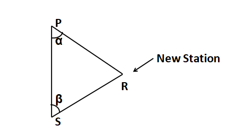
Next what we have to measure the angle of distance and we have to measure the angle between this P and R, and between S and R. so the angle between P & R is alpha (α) and the angle between S & R is beta (β). So, We know the distance between P and S and we know the angle also alpha & beta.
So by this, We can easily locate the new station R. The Main thing is we have to locate a new station by measuring the two reference points. so that’s the second principle. These are the two principals of surveying
The Basics of Chain Survey
The chain is made of galvanized iron and there is the brass handle which is attached in the two ends of the chain. This brass handle is continuing with the chain link, So this is called a link of the chain. This link is one meter. This chain link is a series of one meter.
Totally we get five meters. Every one meter three brass ring is attached and every five meter brass tally is attached. Brass tally is attached to separate the distance. This part of a chain is used in the survey.
Types of Chain used in Survey
There are four types of chain.
1) Metric Chain
This Metric Chain is 20 meters or 30 meter in length. This Metric Chain has 100 links.
2) Engineers Chain
This Engineers Chain is hundred feet long. Engineers Chain has also hundred links.
3) Gunters Chain
This Gunters Chain is 66 feet long. Gunters Chain also has hundred links.
4) Revenue chain
This revenue chain is 33 feet long and the revenue chain has 16 links.

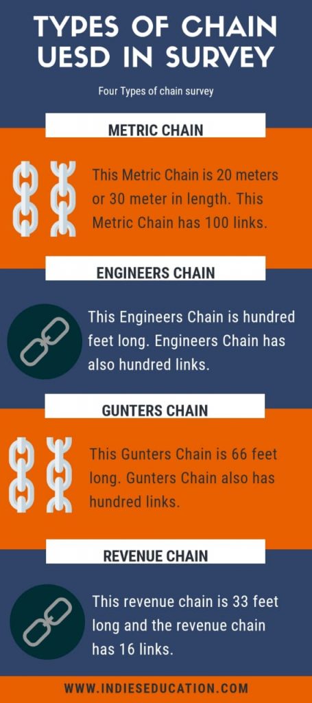
These are the types of chain and also we have learned about its length. This metric chain and Engineers chain are useful for surveying large areas. Gunter’s chain and Revenue chain are used to survey only a smaller area. So, this is the basics of chain and also types of chains used in surveying.
Compass Survey
“Compass is an instrument which can be utilized to measure the path of a survey line with respect to magnetic Meridian.“
The angle between the survey line and the meridian known as the bearing. The use of the compass for measuring the path of a line simplifies the surveying to a great extent.
The difference between prismatic and surveyors compass
Prismatic compass
- The graduation circle is mounted to a broad kind needle. Hence it is not going to rotate with the line of sight.
- At the viewing end, there is a prism.
- Sighting and reading will be executed concurrently.
- The magnetic needle doesn’t act as an index.
- The graduations are in whole circle bearing.
- Graduations are marked inverted since its reflection is read by means of a prism.
- The reading is taken by means of a prism.
- Tripod might or might not be used. it may be held on a stretched hand also.
Surveyors Compass
- Also Known as Circumferentor.
- The graduation circle is mounted to the box. therefore it rotates with the line-of-sight.
- At viewing end, there isn’t any prism. There is just a slit.
- Sighting and viewing can’t be completed concurrently.
- Magnetic needle acts as an index while reading.
- The graduations are in the Quadrant system.
- Graduations are marked straight. They usually are not inverted.
- Take the reading by viewing straight from the top glass
Levelling
Leveling is the way to determine the heights of the point above or below an agreed datum.
Datum is the assumed level surface or line that will be a reference to other points. And benchmark is any permanent reference point that has arbitrary height assigned to it or had an accurately determined height determined by the leveling.

Types of Levelling
1) Simple Leveling
When the difference of level between two points is determined by setting the leveling instrument midway between the points.
2) Differential Levelling
It is also known as continuous or compound leveling.
Differential leveling is adopted when the difference of elevation between the point is large, the points are a great distance apart, and there are obstacles between the points.
3) Longitudinal or Profile Levelling
It is the operation of taking levels along the centerline of any alignment (railway, road etc.) at regular intervals. In this operation, the back sight, the intermediate sight, and foresight readings are taken at regular intervals at every set up of the instrument. The chainages of every point are noted down in the level book. This operation is undertaken to determine the profile of the ground surface along the profile line.
Conclusion
Surveying is the core branch of civil engineering. Every project in the construction industry starts with a survey of the area to be constructed.
You have read the basic information about surveying in this blog which includes objectives, principles, and classification of surveying, plane and geodetic surveying, chain survey, compass survey, and leveling.
Also Read :
- basic Knowledge and Skills for civil engineers in 2020
- Best Seminar Topics of Civil Engineering
- Infrastructure in the Construction Sector 2020
FAQs
Chain Surveying, Compass Surveying, Plane table surveying, Theodolite surveying, Tacheometric surveying, Photographic surveying.
This engineers are take the measurements to decide the boundaries of any property. Their work involve researching land records and measuring distances.
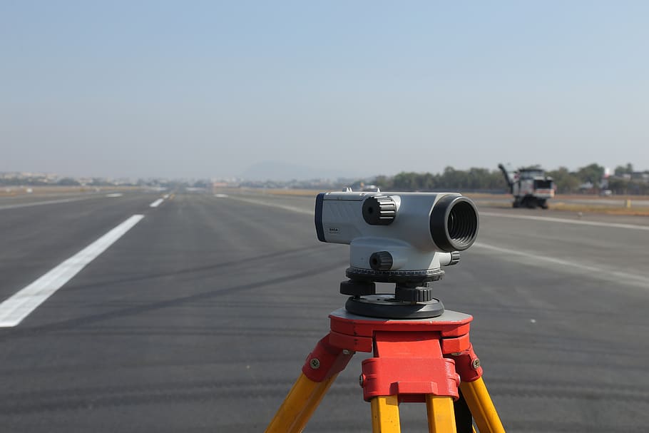
Theodolite, measuring tape, Total station, 3D scanners, level, gps, rod, etc.


